


BoatFishingNavi app for iPhone and iPad
Developer: kagoturi
First release : 18 Sep 2012
App size: 4.37 Mb
This application displays a map of the kml,kmz format and saves the checking point and track record to kml format file.
In order to use the application you need to register map of kml,kmz format.
If the registration of the map, you will be able to view it with the information obtained by the GPS position and map even when offline.
(How to register a map)
Sent an email attachment kml or kmz format file from PC to iphone.
Open incoming mail, press the icon of kml or kmz file, select a BoatFishingNavi.
BoatFishingNavi is started.
Press the "Map/log read" button from the menu of the BoatFishingNavi.
※Display the menu tap the bottom of the screen.
Select the map you want to display
(Note)
Continued use of GPS running in the background can dramatically decrease battery life.
Map data is not included in the application.
Map data, please copy the data(kmz,kmz) via email or USB connection.
For any loss or damage caused by the use of this application we will not take any responsibility.
(Features)
・Log and view GPS track.
・ Mark the position of the screen you want to mark a temporary.
・ Display the map to screen from kml or kmz files.
・ Save track position and point to kml file.
(Description)
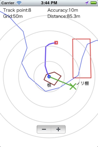
Track point:
Displays the number of recording tracks in the position.
Accuracy:
Displays the current GPS measurement accuracy of meters.
(Screen)
○ Blue: Current position
□ Red: Start position
Blue lines: Track
Green pin: The marked position
Blue Flag and character: Point location, name, time
(Screen operation)
Tap the bottom of the screen: Display the menu.
Tap the screen: Display the zoom button.
Double tap the screen: Change two mode.
"Setting Mode change:ON" only.
Long press the screen: Register and view the destination.
"Setting Destination:ON" only.
Excepting "Setting Compass:rotate the entire screen"
Flick : Scroll the screen.
Excepting "Setting Compass:rotate the entire screen"
Pinch: Expansion of the screen, reducing.
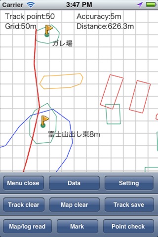
(Menu)
Close: Close menu
Data: Delete upload and copy kmz,kml file.
Setting: Perform settings.
Track Clear: Clear the track logging.
Map clear: Loaded map (kmz,kml file) clears the display.
Track Save: Save track to a kml file.
Map/log read: Load kmz,kml file.
Mark: the green pin, Mark the current position.
Point Check: Point and recorded the name as the current position display a blue flag.
(Setting)
Auto scroll: Scroll the screen as you moving.
Map auto read: Read the map (kml or kmz) automatically at startup.
Edit file name: Edit the save file name.
GPS sleep: Pause the GPS in the background.
Accuracy circle: Show the accuracy circle.
Destination: Register and view the destination.
registering the destination is press and hold the screen.
However, screen rotation mode or auto scroll mode cant register the destination.
Mode change: Change two mode by double tapping on the screen.
"Setting Mode"
Compass type: normal compass
Auto scroll: OFF
grid type: normal grid
"Navigation mode"
Compass type: Auto screen rotation
Auto scroll: ON
grid type: circle
Track line hide: Hide the track line.
Track line width: The width of the track line.
(1 point, 3 points, 5 points)
Map line width: The width of the map (kml or kmz) line.
(x0.5, x1, x2)
Grid type: Select type of grid lines.
(normal grid, circle from the self-position)
Font size: The size of the font.
(13 points, 14 points, 15 points)
Grid size: Spacing of the grid.
(10m, 25m, 50m, 100m, OFF)
Compass Type: Select type of Compass.
(Hidden, normal compass, rotate the entire screen)
Auto save: Automatically save the track log.
Filename is the following automatically by the application startup time.
autosaveyyyyMMddHHmmss.kml
(Minutes, 15 off, 30 minutes)
Info: Show this screen.
Edit point Text:
Editing the name of the registration point.
(Point A ~ Point H)